Lidar Reveals Rectangular Feature on the Western Edge of Rooley Moor

Here is an example of Lidar revealing archaeological sites as in this rectangular (enclosure?) on the western edge of Rooley Moor.

https://houseprices.io/lab/lidar/map?ref=SD8542917625

If you explore around this area you can see many ditches and other features I have mentioned earlier: they are clearly highlighted by the Lidar image.

Man Road Ditch

Man_Road_Ditch_David_Mercer
Looking south towards Man Road Ditch and Knowl Hill, Photo by David Mercer.

Even the name is mystery, “Man Road Ditch”. The ditch is of unknown date and unknown purpose and runs from the foot of Knowl Hill in a NNW direction.

The earliest reference found so far, is in the first series 6″ OS map (1851) of the area.

See the aerial view of the ditch hereNote select “satellite” to see an aerial photograph of the ditch.

Here is a Lidar view

ManRdLidar

Man Road Ditch

The feature that crosses it at the bottom of the image is the turbine access road!

You can see the road crossing the ditch in the photo below:

ManRoad.jpg
Man Road Ditch, being damaged by an access road.

Scout Moor Archaeology

Introduction – Under Construction…

This post will briefly cover the historical background to the area, (including the Forest of Rossendale) to better understand the context of the many archaeological sites in and around Scout Moor.

Exciting Discoveries

There are some exciting newly discovered sites to reveal. As in the case of the adjacent Rooley Moor, the area has never had a thorough archaeological survey, perhaps that is an understatement.

See for Yourself (from the comfort of your browser)

Select one of the links below to see sites of Farmsteads Fecit Lane and Coal Road: (centered on SD 81852 17717).

http://www.aardvarkmap.net/map/7F5LDXBI

To the North of these on Higher Hill (This site is not on any OS maps as far as I know).

http://www.aardvarkmap.net/map/BWM90AKQ

The feature is best viewed with Microsoft Bing Maps birds eye view.

See the sites in Fecit Lane and Coal Rd. as they were in 1851 (surveyed 1844 to 1848) on and old OS map of Lancashire LXXX.

http://maps.nls.uk/view/102344003

Ouch
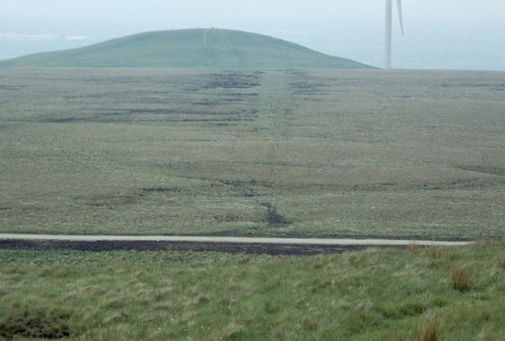
Wind farm road cuts ancient ditch called Man Road Ditch,  of unknown date or purpose.


Before the wind farm
http://www.aardvarkmap.net/mape/7B8ZE88Y

Medieval and other documentation for this area

The extensive body of medieval documentation for the area has been largely ignored by archaeological surveys of the area. This has been covered here.

Missed Sites

Some of the sites archaeological surveys of the adjacent areas have missed include:

  • A ruined medieval manor house (Naden Head) complete with earthworks and early wall
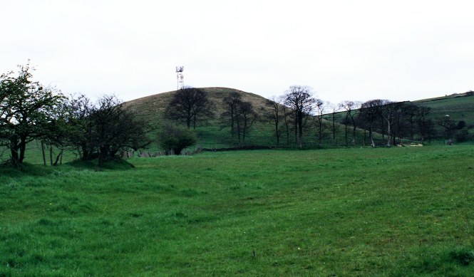
  • Several prehistoric burial sites, including a prominent site on Hunger Hill (see the picture at the beginning of this blog.)
  • Prehistoric Fields on Rooley Moor
  • Several early farmsteads, such as Birchen Holts

Cowpe

There was a vaccary (medieval cattle ranch) somewhere in Cowpe, location not yet verified.

Scout Moor lies mostly in what was the NW of Spotland, a township in the parish of Rochdale, and in what was Bury Parish.

Note
These are the historical areas (which were all in Lancashire), modern boundaries are very different; with the area now divided between Greater Manchester and Lancashire (Rossendale district).

References

Lancashire Forests and the Forest of Rossendale

Newbiggin – History of the Forrest of Rossendale

Medieval Forests – The Lancashire Antiquarian

Springhill website

Aerial Photographs

Google Maps

Lancashire’s Mario map site

Microsoft Bing maps

HER (Historic Environment Record)

Greater Manchester HER

Terminology

Forum on Information Standards in Heritage (FISH) Thesauri

Under Construction…!

Sidholme stone, Rochdale

Image

A curiosity, this one, a large stone beside a stream in Sidholme, north of Rochdale. The area is interesting with early enclosures and stone farmsteads nestling below the prominent Hunger Hill. I have posted two pictures, the first picture shows a rectangular recess cut into the south end of the stone. The second picture is taken from the other side of the stream, looking south east towards Hunger Hill.

Image

Rochdale’s Other Castle

The 1626 Rochdale Manor survey mentions a lesser known “castle” place-name, it is recorded as “Thrustcastel” which means the “leppers castle”. There is a  “castle” is marked on the first series OS map, but this has been cut through by the M62 and is further east than the Newhey site.

ImageImage

I think this is “Thrustcastell” a prominent hill clearly visible just south of the M62 motorway at Newhey, it has a base station on top.

It looks like the product of glacial processes but it could have been used in earlier times or maybe the glacial sand soil was good farmland!

You can see for yourself on Google Earth or Microsoft Bing Maps. It is just north of Newhey at SD936120.

What do you think?


Unruly moors – it’s amazing what you find when you look

There is no substitute for walking areas, even soggy moor land, if you want to find something.

Here are some of the sites I have found in areas that were supposed to have been surveyed by archaeologists. They also said there was “a hiatus in Medieval times”, did they read there own references? I have reproduced some early names from Fishwick’s History of the Parish of Rochdale, many are on Rooley Moor! The name Ding was written Dinge in medieval times. A survey of the area found no medieval records for the area! but mentioned a ‘hiatus’ in medieval times, how many charter are there for the area?

Apart from Dinge we have Bikeden (Bagden), Naden and Prickshaw, for example. There are many medieval charters that relate to the the Ding area, as well as mentions in the Manor Surveys of Rochdale in the 17th. century.

Enclosure and Early Fields at SD 855177

Enclosure on Rooley Moor

The yellow arrows mark the line of the earlier enclosure, which has been “overlayed” with the larger and later fields marked by the stone wall running diagonally to the left of the arrows  and one wall running horizontally in the picture above. Grid reference SD 855177.

Pits SD 859183

This area of small “quarry pits” covers several acres and is easily visible on aerial photographs. Mysteriously they are invisible on maps and on an archaeological survey that was supposed to have walked the are. If they had walked the area they would have stumbled into the pits! This is the clearest indication that the survey failed to find even the most obvious and large archaeological features. They have not just appeared, they can be seen on 1940s black and white photographs and all subsequent aerial photographs.

Would you miss these?

They appear to be like pits, see this link.

Can’t miss these at SD 859183!


see this at http://binged.it/1s4xFUC

Would you miss this barrow?


Good News
You will be glad to know that the ruins of the Old Moorcock were recorded in the survey.


Church Topography in Salford Hundred

Saint Leonard's
Middleton Parish Church - Saint Leonard's

Radcliffe parish church lies at the junction of two streams in the Irwell valley. By contrast Bolton, Bury, Manchester, Middleton, Prestwich and Rochdale all overlook valleys below.

Bolton, Manchester and Middleton all occupy commanding positions, which would also have been good defensive positions.

Radcliffe

In the Domesday book, Radcliffe is recorded as a royal manor (as was Salford).

The location of the churches is worthy of further study. Close to the river the church is bounded by two streams, it is not a hill-top site like Middleton or Prestwich.

Radcliffe Parish Church
Radcliffe Church

Close to the church is Radcliffe Tower, all that remains of the medieval manor of Radcliffe. The  Tower was excavated and surveyed by the Bury Archaeological Group. See this link

Radcliffe Tower


Under Construction.

Research

With so little published archaeological survey and research work undertaken in SE Lancashire, the area offers many opportunities for researchers.

A detailed survey of SE Lancashire (Salford Hundred)  has yet to be undertaken as regards archaeology.

Some ideas for research

  • Urban archaeology – Rochdale, well documented yet little excavation has taken place into medieval Rochdale.
  • Survey of the Pennine foothills and the Moors, many cairns are still unrecorded.
  • Inventory of unpublished excavations.
  • Geophysical survey strategies and benchmarking (which techniques are best suited to local soils?)
  • Surveying rural sites mentioned in medieval documents.
  • Survey of moorland enclosures and assarts.
  • Boundaries in the landscape, from ditches and banks to early stone walls.
  • Pollen analysis, to reveal human impact on the landscape and vegetation over time.
  • Early iron working
  • Early coal mining.
  • Excavations to confirm the nature of particular sites.
  • Moated rectories of Salford Hundred, myth or reality?
  • Priorities for archaeological research.
  • Comprehensive update of archaeological sites on planning GIS (Graphical Information System).

Under construction…

Lord Rochdale’s Magnificent Panelled Room

Magnificent early wooden panelling from Rochdale was transported to Arundel House, London. Read an article about it on the British History Online site here.

‘Arundel House, Old Hall and the Lawns’, Survey of London: volume 17: The parish of St Pancras part 1: The village of Highgate (1936), pp. 46-53. URL: http://www.british-history.ac.uk/report.aspx?compid=65011&strquery=Rochdale Date accessed: 11 April 2010.

Naden Head Manor House

nadenbirchenholts

Naden was first mentioned in a deed of 1107 and again in the 13thC. in the Coucher Book of Whalley Abbey. Many ruins can still be seen in the area.

Naden_wall
Wall to the west of Naden Head

Naden Head has commanding views down the Naden Valley and over the Manchester Plain. It is sheltered by a shale bank, immediately to the west of the ruins.

Below the manor can be seen boundary walls an cultivation that probably range from medieval to more recent drainage ditches and cultivation terraces.

A survey of the area is needed to record the landscape context of Naden Head, and historic land use.

A Manor with a view
A Manor with a view

Naden Head Manor
Naden Head Manor (site of)

Naden Head From the air

See an aerial view of Naden Head  here. An old OS map of the area can be found here

Early Wall

This wall can be seen to the SW of Naden Head.

Early Wall and Ditch - Naden
Early Wall and Ditch – Naden
Boundary Wall, looking SW

History

A manor house, belonging to a member of the Holt family, who even held their own court, is mentioned in the 16th C. In the 1626 Rochdale Manor Survey it is mentioned as “a capital messuage”. The manor house ruins can still be seen as well as an early boundary wall and ditch.

Extract from 1st Series OS Map of Naden Head and Naden Dean

1851NHeadNDean

Read more about the history of Naden here.

Naden Dean

The ruins of Naden Dean farmhouse (mentioned in the early 17th. C.) can be seen to the south of the boundary wall.

Naden Dean

Thanks

United Utilities own the land and it is open access.

Thanks to English Heritage’s Al Oswald for visiting this and other sites and giving me a fascinating insight into the historic landscape of the area.